The excessively wet month of June continues, and strong storms Saturday night dropped 3 to 4 inches of rain in many areas, including the City of Buffalo.
The heavy rain caused localized flooding in Buffalo and many other areas. Sunday, the City of Buffalo put out a request to residents via social media to limit heavy water usage such as laundry, dishwashers, and other higher volume water usage due to very high flows experienced by the city’s wastewater collection system.
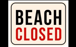
The city has also temporarily closed the beach area at Sturges Park, and the fishing docks in that area as water testing is done to be sure that the floodwaters did not carry contaminants that could compromise water quality.
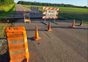
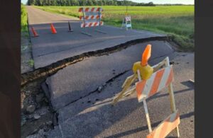
Elsewhere, road closures were put in place due either to flooded roadways, or roadway sections that were washed out or damaged.
One such location is at 10th Street Northeast and Farmington Avenue east of Buffalo where heavy water flow caused a section of the road surface to collapse. That section of roadway was closed Sunday, and will presumably be closed until crews can make repairs.
(photos: Kendell Kubasch / KRWC Radio)
Meanwhile, many residents in east and southeastern Wright County are watching levels on the Crow River and the South Fork Crow River. Water levels had been going down after high levels earlier in the month prompted by heavy rain, but the weekend storms have sent those levels back into, or close to flood stage in several areas.
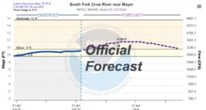
In Mayer, a flood warning is in effect on the South Fork Crow River where levels are expected to rise back over the 11 foot minor flood stage on Monday and the National Weather Service’s Water Prediction Service says the level should top out at about 12 feet on Thursday.
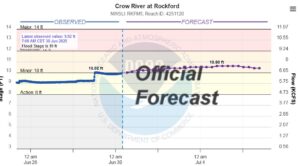
A flood warning is also issued for the community of Rockford, where the Crow River level is currently at the 10 foot minor flood stage, and is expected to crest at around 10.6 feet on Saturday.
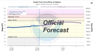
The South Fork of the Crow River in Delano is also running high, but so far, is predicted to stay below the minor flood stage of 16.5 feet. The Water Prediction Service expects a rise to 16.1 feet by Friday, July 4th. That level will be very high, but just below flood stage.
This will be the second consecutive year where the 4th of July festivities throughout Wright County will be carefully planned around potential high water.
While Wright County had heavy rain over the weekend, communities as close to us as Waconia reportedly had tornado damage from the Saturday overnight storms.